BY: ELENA ROCHE
Topanga Canyon offers many hiking trails. Some trailheads have official entries with paid parking lots, facilities and park rangers. Some trails start at the end of private neighborhood streets and are known by locals only. If you stay with us at Topanga Canyon Inn you can hike like a local. After check-in, you will not need to drive any farther. Just get your hiking gear on and start hiking. Note these trails are not readily available to the general public because of private roads and no parking and bathroom facilities at trail heads. This makes your experience all that more unique.
1. Eagle Rock Loop Trail, 5 miles, Highest elevation 2104 ft., lowest elevation 1300 ft., 2 - 3 hours
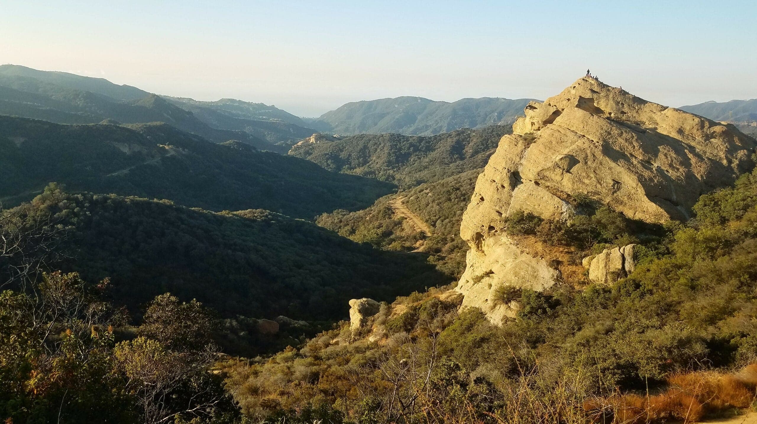
Hike up our private road by turning right from the driveway of Topanga Canyon Inn. There are just a few more tucked away houses past our Inn and views of Topanga Canyon open up, so it feels like hiking already. In one-third of a mile you will reach the end of our private road where the trail starts at a gate with park signs. The trail is a bit rough and bouldery in the beginning but gets better farther up. While you hike on this trail, you will pass a gnarly Dragon Rock with a small cave near the top. In the near distance you will be passing and going around a triangular shaped Rochemont Rock, which you see from the windows of our Inn. As you continue past Dragon Rock, look back at the cliffs on the other side of it. In spring a Redtailed Hawk couple nests on one of the ledges and one of them is often seen perched on the very top. The views get better and better as you gain elevation. After about 0.8 of a mile on this trail you reach the Loop Trail, a T shaped intersection. Here you will be near the top of the ridge from where Temescal Canyon starts. To the right will be Eagle-Elephant Rock, straight ahead the Pacific Ocean, down below Eagle Springs and to the left the highest point on this trail. Turn right at this T. Just past Eagle-Elephant Rock, the trail starts to wind down. When you reach Musch trail junction take a sharp left. The lowest point on the trail, Eagle Springs runs in spring, stays wet during summer and dries up for the rest of the year. After this point, the trail will slowly climb up to Hub Junction. There are some park signs with an explanation of local geology, an overhang for shade and a bathroom. Go up a hill, to the left of the bathroom to stay on Loop Trail that keeps slowly climbing up to the highest point, 2104 ft. You can't miss it. This is a beautiful spot with panoramic views of the area from San Fernando Valley and Mt. Wilson to the Pacific Ocean framed by the Santa Monica Mountains. From this point, it is all downhill hiking. Be sure to turn left at the T, Cheney Trail, that will take you back to our private road and our Inn.
2. Musch Trail Loop, 5 miles, Highest Elevation 1933 ft., lowest elevation 1100 ft., 2 - 3 hours
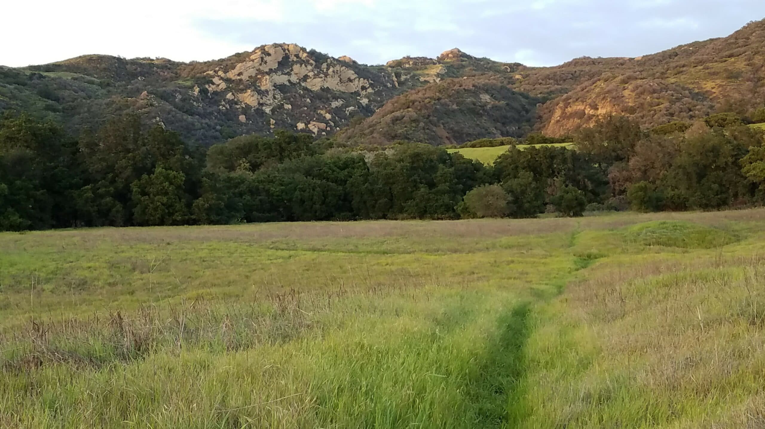
Large portion of Musch Trail goes over gentle rolling terrain of former Musch Ranch. Green meadows alternating with oak groves are full of wild flowers and wild oats in spring. To hike this trail walk out of our Inn and take a left on Callon Drive. Walk down the road, to the west end of Callon or where the very last house is located. Turn right onto a small foot trail that goes around this property. Look for a little sign about leashing your dogs to protect wildlife. At this point take a left on the small trail that goes down and through some big old oaks. The trail will wind down to a small creek. Cross the creek and follow the trail through Musch Meadows alternating with oak groves. When you reach a paved road take a left and go to the Musch Camp. This small camping grounds have bathrooms., a good place to take a break. From the camp take Backbone trail that goes up and up a mountain side toward Eagle Rock. Once you reach East Topanga Fire Road, a wide dirt road, turn left and follow it up to the Eagle Rock. If you visit this rock formation be sure to turn right, back on the fire road. In less than a quarter of a mile take a left on Cheney Trail, a small trail. Follow it down the mountain all the way to the Inn. If you would like to hike this trail talk to us first. Some trail signs disappear suddenly and so trails may not be marked in some places. We hike these paths all the time and can brief you on the details and show you these trails on Google Maps.
3. Vanalden Vista Point Loop, 8 miles, Highest Elevation 2100ft. , Lowest Elevation 1000 ft., 3 - 4 hours
This relatively seldom visited spot in the Santa Monica Mountains is very beautiful. It is a high point on the ridge from where you may view the whole Topanga Canyon, distant horse ranches and the San Fernando Valley, which is part of Greater Los Angeles. From Topanga Canyon Inn take a left on Callon Drive and follow it down to Sylvania Lane. Turn right on Sylvania and go down to Paradise Lane. Turn right on Paradise and go all the way to the end of it where the last property is. Take a left on Yedvard Canyon trail and follow it along the creek bed and then up the slope of the mountain past towering rock formations on the left. Once you reach the trail that runs along the ridge, take a right and follow it all the way to the highest point with a graded top. This is Vanalden Vista Point. Enjoy the views, try to find the location of our inn from here, we look tiny in comparison. From Vanalden Vista Point get back on the trail and head toward the water department's facility that is surrounded by trees and a fence. Just past this facility is Mulholland Drive, the unpaved portion designated for hiking, biking and horseback riding only. Turn right on Mullholand and follow it along the ridge line to the next big junction with Temescal Fire Road. Turn right on Temescal and hike to Hub Junction. At this point there is a nicely built overhang with posters about the geology of the area, views of Cathedral Rocks and a bathroom. Take a sharp right, around the bathroom and up Backbone Trail it is a dirt fire road. Hike to where you are close to Eagle Rock, but before you get too close turn right on Cheney Trail. Cheney Trail is the one that starts at the bottom of some huge sandstone boulders. Cheney Trail goes down and takes you out of Topanga State Park. Keep following the neighborhood's private road all the way to our Inn. Some trail signs disappear suddenly and so trails may not be marked in some places. We hike these paths all the time and can brief you on the details and show you these trails on Google Maps.
If you are ready to hike like a Topanga local click SEE AVAILABILITY. or visit our website to learn more about rooms and what we offer.